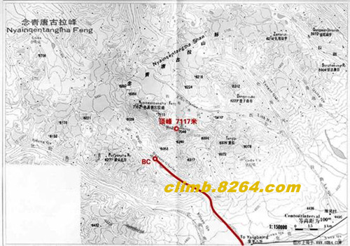
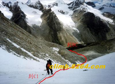
Ninian Peak Introduction: Mountain Profile: The Nyainqentanglha Mountain Range stands in the middle of the Tibetan Plateau and is one of the watersheds in the northern Tibetan region of northern Tibet. It is also one of the watersheds of the Tibetan Plateau inland flow area and the Indian Ocean. Its ridge line, which stretches for hundreds of kilometers, is located west of Dangxiong-Yangbajing. The general peaks are all above 5500-6000 meters, and the peaks are sharp. More than 20 kilometers north of Yangbajing, on the west side of the Qinghai-Tibet Highway, there are four peaks in the northwest-southeast direction that line the Nyainqentanglha Mountain Range with a height of 7162 meters and 7111 meters. 7117 meters and 7,064 meters. The four peaks and their surrounding area were once subjected to strong Quaternary glaciers. Today's steeper mountains, avalanches and ice collapses are widespread. (attached with detailed mountain data) Climate conditions: As the Nyainqentanglha Peak is located in the hinterland of the mainland, the barrier function of the mountains blocks the cold currents in the northwest and the warm currents in the Indian Ocean. It basically belongs to a semi-arid continental climate with an annual rainfall of 300-400 mm. From mid-May to mid-September each year is the rainy season in the region. This time concentrates 80%-90% of the annual precipitation. The weather in the rainy season is also very complex and volatile. The showers, hailstorms, thunderstorms, lightning, etc. often occur throughout the day. A variety of weather phenomena, and these are the enemies of mountaineering activities. Snowstorms often occur in spring, and mountaineering activities are generally preferred from May to September. Climbing history: time Team Climbing situation 1986 Japan Northeastern University Mountaineering Team Three people summit 1990 Austrian mountaineering team Summit 1992 Peking University Mountaineering Team Three people summit 1998 Peking University climbs with Tibet Mountaineering Team Uncapped 1999 Tsinghua University Mountaineering Team Uncapped 2000 Several foreign mountaineering teams climb Most of the summit 2001 Tsinghua University Mountaineering Team 5 people summit 2005 Tsinghua University Mountaineering Team 4 people summit 2006 Xiamen University Mountaineering Team Uncapped 2007 Beihang University 4 people summit Note: The climbing record is incomplete statistics Into the mountain route From Lhasa, head toward Dangxiong along the Qinghai-Tibet Highway and turn left at the 3779KM road monument, about 110 kilometers from Lhasa. Go straight along the grassland until you climb the village of Nudo. Build RC (temporary camp). Hire yak into BC (base camp) here. Overall analysis, Lhasa to RC traffic is convenient. RC to BC, the route is longer and needs calves to be transported. Climbing route and situation analysis [RC-BC] BC: 4800m above sea level Major hazards: none Detailed description: From Dangxiong, go along the Qinghai-Tibet Highway and pass a large Jingluo River about 100 meters. The road crosses the river. However, after the bridge, turn right into the mountain along the riverside Tongning Zhongxiang. At the end of the road is a small village on the Weihe River as an RC site. From Dangxiong to RC, the truck ride takes about 3 hours. RC is about 4,800 meters above sea level. In the RC assembly yak and humming horse transport equipment, team members walk to BC. After a river, after passing through a village, it has been going up along the valley. The traditional BC site is located not far below Chong Nuo Lake. The terrain is flat, close to the water source, sheltered from the wind and away from the danger of rolling stones. Distance from RC to BC is about 12 kilometers, walking time is about 4-10 hours depending on player status and weather. BC is about 5300 meters above sea level. [BC-C1] C1: 5900m above sea level The main danger: Rolling stones Detailed description: From BC, climb around Nuohu Lake and follow the gravel slope up to the glaciers. Avoid the ice tongue end and look for the right place to cut the glacier from the left side. The topography of the glaciers is basically a mixture of bright ice and glacial boulder, and the slope is steep, reaching more than 30 degrees. This section of the road requires the use of an ice pick, and every time it goes up, it must first check the degree of ice melting around the ice cone. After rising about 100 meters, the terrain gradually changes from ice slopes to snow slopes, and snow cones can be used for road construction. Go up the glaciers and reach the saddle above the glaciers to build C1. Curtain Iron Baton,Metal Curtain Pole,Metal Curtain Rods,Window Curtain Rods HANGZHOU AG MACHINERY CO.,LTD , https://www.famourdecor.com